
North Wales topographic map
Interactive map
Click on the map to display elevation.
About this map
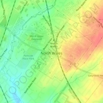
Name: North Wales topographic map, elevation, terrain.
Location: North Wales, Montgomery County, Pennsylvania, United States (40.20362 -75.28450 40.21917 -75.26415)
Average elevation: 113 m
Minimum elevation: 85 m
Maximum elevation: 141 m
Other topographic maps
Click on a map to view its topography, its elevation and its terrain.
Willow Grove
United States > Pennsylvania > Montgomery County > Upper Moreland Township
Average elevation: 91 m
Bob Case Park
United States > Pennsylvania > Montgomery County > Upper Merion Township > King of Prussia > Sweet Briar
Average elevation: 45 m
Audubon
United States > Pennsylvania > Montgomery County > Lower Providence Township > Audubon
Average elevation: 55 m