
Make a donation
Gear up for your next adventure:
As an Amazon Associate, this site earns from qualifying purchases at no extra cost to you.
Phakamisa topographic map
Click on the map to display elevation.
Make a donation
Gear up for your next adventure:
As an Amazon Associate, this site earns from qualifying purchases at no extra cost to you.
About this map
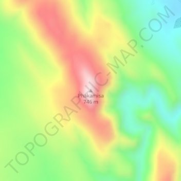
Name: Phakamisa topographic map, elevation, terrain.
Average elevation: 499 m
Minimum elevation: 292 m
Maximum elevation: 753 m
Make a donation
Gear up for your next adventure:
As an Amazon Associate, this site earns from qualifying purchases at no extra cost to you.
Other topographic maps
Click on a map to view its topography, its elevation and its terrain.
Mkuze River
South Africa > KwaZulu-Natal > Zululand District Municipality > uPhongolo Local Municipality
Average elevation: 355 m
Pongolapoort Dam
South Africa > KwaZulu-Natal > Zululand District Municipality > uPhongolo Local Municipality
Average elevation: 261 m
Phongola Nature Reserve
South Africa > KwaZulu-Natal > Zululand District Municipality > uPhongolo Local Municipality
Average elevation: 157 m
Thalu
South Africa > KwaZulu-Natal > Zululand District Municipality > uPhongolo Local Municipality
Average elevation: 803 m
Make a donation
Gear up for your next adventure:
As an Amazon Associate, this site earns from qualifying purchases at no extra cost to you.