
Community Lake topographic map
Click on the map to display elevation.
About this map
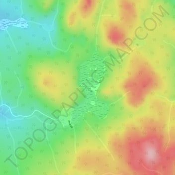
Name: Community Lake topographic map, elevation, terrain.
Average elevation: 1,399 m
Minimum elevation: 1,323 m
Maximum elevation: 1,490 m
Other topographic maps
Click on a map to view its topography, its elevation and its terrain.
Mount Cahilty
Canada > British Columbia > Thompson-Nicola Regional District > Area O (Lower North Thompson)
Average elevation: 1,736 m
Leonie Lake
Canada > British Columbia > Thompson-Nicola Regional District > Area O (Lower North Thompson)
Average elevation: 1,107 m
Little Fort
Canada > British Columbia > Thompson-Nicola Regional District > Area O (Lower North Thompson)
Average elevation: 521 m
Dagger Lake
Canada > British Columbia > Thompson-Nicola Regional District > Area O (Lower North Thompson)
Average elevation: 1,484 m
Spectacle Lake
Canada > British Columbia > Thompson-Nicola Regional District > Area O (Lower North Thompson)
Average elevation: 1,428 m
Dunn Peak
Canada > British Columbia > Thompson-Nicola Regional District > Area O (Lower North Thompson)
Average elevation: 2,132 m
Spider Lake
Canada > British Columbia > Thompson-Nicola Regional District > Area O (Lower North Thompson)
Average elevation: 1,358 m