
Clavas topographic map
Interactive map
Click on the map to display elevation.
About this map
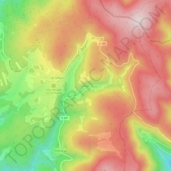
Name: Clavas topographic map, elevation, terrain.
Average elevation: 1,180 m
Minimum elevation: 906 m
Maximum elevation: 1,380 m
Other topographic maps
Click on a map to view its topography, its elevation and its terrain.
Les Sétoux
France > Auvergne-Rhône-Alpes > Haute-Loire > Riotord
Les Sétoux, Riotord, Yssingeaux, Haute-Loire, Auvergne-Rhône-Alpes, France métropolitaine, 43220, France
Average elevation: 1,145 m