
Basta Tahta topographic map
Interactive map
Click on the map to display elevation.
About this map
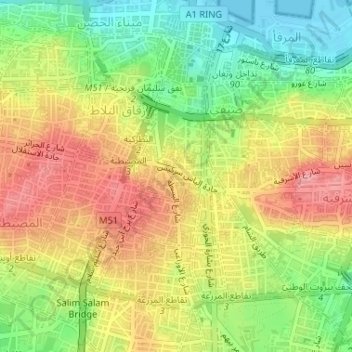
Name: Basta Tahta topographic map, elevation, terrain.
Location: Basta Tahta, Bashura, Beirut Governorate, Lebanon (33.88540 35.50017 33.89017 35.50849)
Average elevation: 58 m
Minimum elevation: -1 m
Maximum elevation: 115 m
Other topographic maps
Click on a map to view its topography, its elevation and its terrain.
Syoufi
Lebanon > Beirut Governorate > Syoufi
Syoufi, Achrafieh, Beirut Governorate, Lebanon
Average elevation: 43 m
El Hamra
Lebanon > Beirut Governorate > El Hamra
El Hamra, Ras Beirut, Beirut Governorate, N/A, Lebanon
Average elevation: 37 m