
Make a donation
Gear up for your next adventure:
As an Amazon Associate, this site earns from qualifying purchases at no extra cost to you.
Cerro Torre topographic map
Click on the map to display elevation.
Make a donation
Gear up for your next adventure:
As an Amazon Associate, this site earns from qualifying purchases at no extra cost to you.
About this map
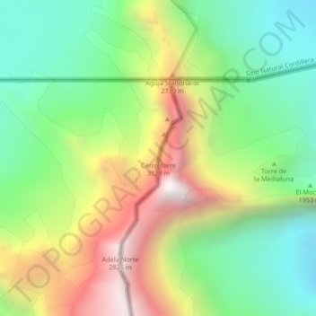
Name: Cerro Torre topographic map, elevation, terrain.
Average elevation: 1,916 m
Minimum elevation: 1,268 m
Maximum elevation: 2,866 m
Make a donation
Gear up for your next adventure:
As an Amazon Associate, this site earns from qualifying purchases at no extra cost to you.
Other topographic maps
Click on a map to view its topography, its elevation and its terrain.
Hanover Island
Chile > Magallanes and Chilean Antarctica Region > Provincia de Última Esperanza
Average elevation: 148 m
Isla Jorge Montt
Chile > Magallanes and Chilean Antarctica Region > Provincia de Última Esperanza
Average elevation: 134 m
Isla Chatham
Chile > Magallanes and Chilean Antarctica Region > Provincia de Última Esperanza
Average elevation: 162 m
Mornington Island
Chile > Magallanes and Chilean Antarctica Region > Provincia de Última Esperanza
Average elevation: 63 m
Make a donation
Gear up for your next adventure:
As an Amazon Associate, this site earns from qualifying purchases at no extra cost to you.
Mornington Island
Chile > Magallanes and Chilean Antarctica Region > Provincia de Última Esperanza
Average elevation: 63 m
Duke of York Island
Chile > Magallanes and Chilean Antarctica Region > Provincia de Última Esperanza
Average elevation: 65 m
Torres del Paine
Chile > Magallanes and Chilean Antarctica Region > Provincia de Última Esperanza
Average elevation: 637 m
Torres del Paine
Chile > Magallanes and Chilean Antarctica Region > Provincia de Última Esperanza
Average elevation: 637 m
Make a donation
Gear up for your next adventure:
As an Amazon Associate, this site earns from qualifying purchases at no extra cost to you.
Glaciar Spegazzini Ramal Sur
Chile > Magallanes and Chilean Antarctica Region > Provincia de Última Esperanza
Average elevation: 1,661 m
Valle Ascensio
Chile > Magallanes and Chilean Antarctica Region > Provincia de Última Esperanza > Torres del Paine
Average elevation: 1,060 m
Isla Valenzuela
Chile > Magallanes and Chilean Antarctica Region > Provincia de Última Esperanza
Average elevation: 139 m
Brüggen Glacier
Chile > Magallanes and Chilean Antarctica Region > Provincia de Última Esperanza
Average elevation: 1,263 m
Make a donation
Gear up for your next adventure:
As an Amazon Associate, this site earns from qualifying purchases at no extra cost to you.
Torres del Paine
Chile > Magallanes and Chilean Antarctica Region > Provincia de Última Esperanza
Average elevation: 637 m
Isla Madre de Dios
Chile > Magallanes and Chilean Antarctica Region > Provincia de Última Esperanza
Average elevation: 105 m
Isla Cabrera
Chile > Magallanes and Chilean Antarctica Region > Provincia de Última Esperanza
Average elevation: 80 m
Dickson Lake
Chile > Magallanes and Chilean Antarctica Region > Provincia de Última Esperanza > Torres del Paine
Average elevation: 824 m
Make a donation
Gear up for your next adventure:
As an Amazon Associate, this site earns from qualifying purchases at no extra cost to you.
Torres del Paine
Chile > Magallanes and Chilean Antarctica Region > Provincia de Última Esperanza
Average elevation: 637 m
Torres del Paine
Chile > Magallanes and Chilean Antarctica Region > Provincia de Última Esperanza
Average elevation: 637 m