
Pulau Biak topographic map
Interactive map
Click on the map to display elevation.
About this map
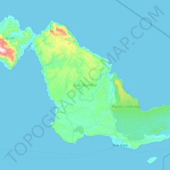
Name: Pulau Biak topographic map, elevation, terrain.
Location: Pulau Biak, Supiori, Papua, Indonesia (-1.19998 135.70844 -0.68516 136.38693)
Average elevation: 49 m
Minimum elevation: 0 m
Maximum elevation: 941 m
Biak covers an area of 2,455 km2 (948 sq mi) The island is 72 km (45 mi) long and 37 km (23 mi) wide at its widest point. The highest point is approximately 740 meters elevation, located in the northwest of the island.