
Make a donation
Gear up for your next adventure:
As an Amazon Associate, this site earns from qualifying purchases at no extra cost to you.
Cosby topographic map
Click on the map to display elevation.
Make a donation
Gear up for your next adventure:
As an Amazon Associate, this site earns from qualifying purchases at no extra cost to you.
About this map
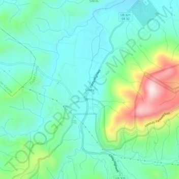
Name: Cosby topographic map, elevation, terrain.
Average elevation: 483 m
Minimum elevation: 378 m
Maximum elevation: 787 m
Make a donation
Gear up for your next adventure:
As an Amazon Associate, this site earns from qualifying purchases at no extra cost to you.
Other topographic maps
Click on a map to view its topography, its elevation and its terrain.
Newport
United States > Tennessee > Cocke County
In 1880, Canadian-born entrepreneur Alexander Arthur (1846–1912), representing the Scottish Carolina Timber and Land Company, arrived in Newport with ambitious plans to log the Pigeon valley. Arthur's plan called for the construction of a series of dams and booms which would be used to move logs from the…
Average elevation: 372 m