
Thank you for supporting this site ❤️
Make a donation
Make a donation
Gear up for your next adventure:
As an Amazon Associate, this site earns from qualifying purchases at no extra cost to you.
Vagen topographic map
Click on the map to display elevation.
Thank you for supporting this site ❤️
Make a donation
Make a donation
Gear up for your next adventure:
As an Amazon Associate, this site earns from qualifying purchases at no extra cost to you.
Vagen
Vagen ist ein Ortsteil der Gemeinde Feldkirchen-Westerham im Landkreis Rosenheim. Das Pfarrdorf liegt auf einer Höhe von 525,7 m ü. NN. Vor der Gemeindegebietsreform 1972 war Vagen eine eigenständige Gemeinde.
Thank you for supporting this site ❤️
Make a donation
Make a donation
Gear up for your next adventure:
As an Amazon Associate, this site earns from qualifying purchases at no extra cost to you.
About this map
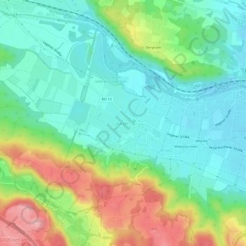
Name: Vagen topographic map, elevation, terrain.
Average elevation: 564 m
Minimum elevation: 509 m
Maximum elevation: 679 m
Thank you for supporting this site ❤️
Make a donation
Make a donation
Gear up for your next adventure:
As an Amazon Associate, this site earns from qualifying purchases at no extra cost to you.