
Make a donation
Gear up for your next adventure:
As an Amazon Associate, this site earns from qualifying purchases at no extra cost to you.
Neydens topographic map
Click on the map to display elevation.
Make a donation
Gear up for your next adventure:
As an Amazon Associate, this site earns from qualifying purchases at no extra cost to you.
About this map
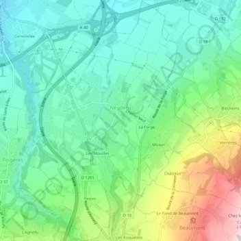
Name: Neydens topographic map, elevation, terrain.
Average elevation: 585 m
Minimum elevation: 471 m
Maximum elevation: 851 m
Make a donation
Gear up for your next adventure:
As an Amazon Associate, this site earns from qualifying purchases at no extra cost to you.
Other topographic maps
Click on a map to view its topography, its elevation and its terrain.
Les Frasserands
France > Auvergne-Rhône-Alpes > Upper Savoy > Chamonix-Mont-Blanc > Les Frasserands
Average elevation: 1,704 m
Sixt-Fer-à-Cheval
France > Auvergne-Rhône-Alpes > Upper Savoy > Sixt-Fer-à-Cheval > Sixt-Fer-à-Cheval
Average elevation: 1,127 m
Mont Maudit / Monte Maudit
France > Auvergne-Rhône-Alpes > Upper Savoy > Chamonix-Mont-Blanc
Average elevation: 3,871 m
Make a donation
Gear up for your next adventure:
As an Amazon Associate, this site earns from qualifying purchases at no extra cost to you.