
Killaloe Municipal District topographic map
Interactive map
Click on the map to display elevation.
About this map
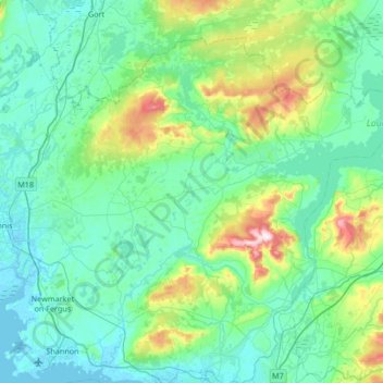
Name: Killaloe Municipal District topographic map, elevation, terrain.
Location: Killaloe Municipal District, County Clare, Munster, Ireland (52.71607 -8.95344 53.04215 -8.28242)
Average elevation: 85 m
Minimum elevation: -2 m
Maximum elevation: 530 m
Other topographic maps
Click on a map to view its topography, its elevation and its terrain.
Cliffs of Moher
Cliffs of Moher, Ballysteen ED, West Clare Municipal District, County Clare, Munster, Ireland
Average elevation: 55 m
Connolly
Connolly, Kinturk ED, West Clare Municipal District, County Clare, Munster, Ireland
Average elevation: 96 m
Ruan
Ruan, West Clare Municipal District, County Clare, Munster, Ireland
Average elevation: 22 m
Broadford
Broadford, Kilseily ED, Killaloe Municipal District, County Clare, Munster, Ireland
Average elevation: 95 m