
Blancs-Coteaux topographic map
Interactive map
Click on the map to display elevation.
About this map
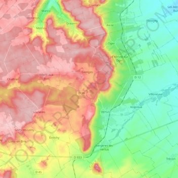
Name: Blancs-Coteaux topographic map, elevation, terrain.
Average elevation: 166 m
Minimum elevation: 84 m
Maximum elevation: 253 m
Other topographic maps
Click on a map to view its topography, its elevation and its terrain.
Vertus
France > Grand Est > Marne > Blancs-Coteaux
Vertus, Blancs-Coteaux, Épernay, Marne, Grand Est, France métropolitaine, 51130, France
Average elevation: 158 m
Oger
France > Grand Est > Marne > Blancs-Coteaux
Oger, Blancs-Coteaux, Épernay, Marne, Grand Est, France métropolitaine, 51190, France
Average elevation: 164 m