
Make a donation
Gear up for your next adventure:
As an Amazon Associate, this site earns from qualifying purchases at no extra cost to you.
Camerig topographic map
Click on the map to display elevation.
Make a donation
Gear up for your next adventure:
As an Amazon Associate, this site earns from qualifying purchases at no extra cost to you.
Camerig
Camerig ligt aan de rand van het Vijlenerbos op een hoogte van circa 160-180 meter boven NAP. Vanuit deze plek heeft men een goed uitzicht over het Geuldal, de oostelijke Ardennen en het noorden van de Eifel. Bij Camerig mondden verschillende beken uit in de Geul, van zuid naar noord de Belleterbeek, Lousbergbeek, Lingbergbeek, Klopdriesscherbeek en Camerigerbeek.
Make a donation
Gear up for your next adventure:
As an Amazon Associate, this site earns from qualifying purchases at no extra cost to you.
About this map
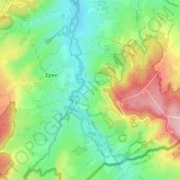
Name: Camerig topographic map, elevation, terrain.
Location: Camerig, Vijlen, Vaals, Limburg, Nederland, 6294 NB, Nederland (50.75327 5.90592 50.79327 5.94592)
Average elevation: 166 m
Minimum elevation: 102 m
Maximum elevation: 274 m
Make a donation
Gear up for your next adventure:
As an Amazon Associate, this site earns from qualifying purchases at no extra cost to you.