
Make a donation
Gear up for your next adventure:
As an Amazon Associate, this site earns from qualifying purchases at no extra cost to you.
Sugar Land topographic map
Click on the map to display elevation.
Make a donation
Gear up for your next adventure:
As an Amazon Associate, this site earns from qualifying purchases at no extra cost to you.
Sugar Land
Sugar Land is located in northeast Fort Bend County, 20 miles (32 km) southwest of downtown Houston. It is bordered by Houston to the northeast, and by Stafford, Missouri City, and Meadows Place to the east. According to the United States Census Bureau, the city of Sugar Land has a total area of 34.0 square miles (88.1 km2), of which 32.4 square miles (83.9 km2) are land and 1.6 square miles (4.2 km2), or 4.82%, are covered by water. The elevation of most of the city is between 70 and 90 feet (21 and 27 m) above sea level. The elevation of Sugar Land Regional Airport (SGR) is 82 feet (25 m).
Make a donation
Gear up for your next adventure:
As an Amazon Associate, this site earns from qualifying purchases at no extra cost to you.
About this map
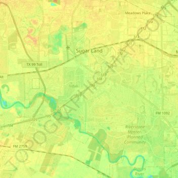
Name: Sugar Land topographic map, elevation, terrain.
Location: Sugar Land, Fort Bend County, Texas, United States (29.51252 -95.69811 29.66187 -95.58050)
Average elevation: 24 m
Minimum elevation: 8 m
Maximum elevation: 33 m
Make a donation
Gear up for your next adventure:
As an Amazon Associate, this site earns from qualifying purchases at no extra cost to you.
Other topographic maps
Click on a map to view its topography, its elevation and its terrain.
Brazos Bend State Park
United States > Texas > Fort Bend County > Alvin
Brazos Bend State Park occupies land bordering the Brazos River and includes within its boundaries low-lying areas left over from the River's previous meanderings. Pre-Columbian inhabitants included a series of Native American groups, most notably the Karankawa. The land passed through a variety of landowners'…
Average elevation: 17 m
Make a donation
Gear up for your next adventure:
As an Amazon Associate, this site earns from qualifying purchases at no extra cost to you.
Make a donation
Gear up for your next adventure:
As an Amazon Associate, this site earns from qualifying purchases at no extra cost to you.
Sienna (Brazos River) Park
United States > Texas > Fort Bend County > Missouri City
Average elevation: 20 m
Make a donation
Gear up for your next adventure:
As an Amazon Associate, this site earns from qualifying purchases at no extra cost to you.
Make a donation
Gear up for your next adventure:
As an Amazon Associate, this site earns from qualifying purchases at no extra cost to you.