
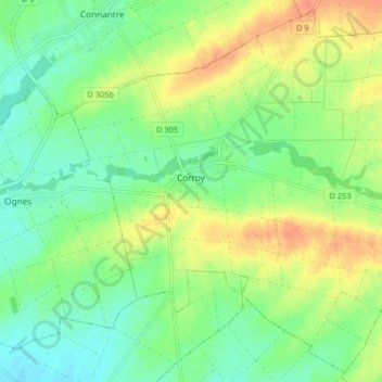
Corroy topographic map
Interactive map
Click on the map to display elevation.
About this map
Name: Corroy topographic map, elevation, terrain.
Average elevation: 107 m
Minimum elevation: 90 m
Maximum elevation: 130 m
Other topographic maps
Click on a map to view its topography, its elevation and its terrain.
Isles-sur-Suippe
France > Grand Est > Marne > Isles-sur-Suippe
Isles-sur-Suippe, Reims, Marne, Grand Est, Metropolitan France, 51110, France
Average elevation: 92 m
Le Gramp le Loup
France > Grand Est > Marne > Dommartin-Varimont
Le Gramp le Loup, Dommartin-Varimont, Châlons-en-Champagne, Marne, Grand Est, Metropolitan France, 51330, France
Average elevation: 184 m
Charleville
Charleville, Épernay, Marne, Grand Est, Metropolitan France, 51120, France
Average elevation: 203 m