
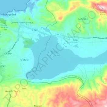
Lac de Miragoâne topographic map
Interactive map
Click on the map to display elevation.
About this map
Name: Lac de Miragoâne topographic map, elevation, terrain.
Average elevation: 150 m
Minimum elevation: 0 m
Maximum elevation: 613 m
Other topographic maps
Click on a map to view its topography, its elevation and its terrain.
La Hatte
Haïti > Département de l'Ouest > Commune Petit-Goâve > La Hatte
La Hatte, Commune Petit-Goâve, Arrondissement de Léogâne, Département de l'Ouest, HT-6220, Haïti
Average elevation: 40 m
1re Bino (Première Plaine)
Haïti > Département de l'Ouest > Commune Petit-Goâve
1re Bino (Première Plaine), Commune Petit-Goâve, CMRP, Arrondissement de Léogâne, Département de l'Ouest, Haïti
Average elevation: 330 m
Petit-Goâve
Haïti > Département de l'Ouest > Commune Petit-Goâve
Petit-Goâve, Commune Petit-Goâve, Arrondissement de Léogâne, Département de l'Ouest, 6220, Haïti
Average elevation: 100 m
Commune Petit-Goâve
Haïti > Département de l'Ouest > Commune Petit-Goâve
Commune Petit-Goâve, CMRP, Arrondissement de Léogâne, Département de l'Ouest, Haïti
Average elevation: 389 m
11e Ravine Sèche
Haïti > Département de l'Ouest > Commune Petit-Goâve
11e Ravine Sèche, Commune Petit-Goâve, CMRP, Arrondissement de Léogâne, Département de l'Ouest, HT-6220, Haïti
Average elevation: 511 m