
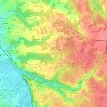
Les Deaux topographic map
Interactive map
Click on the map to display elevation.
About this map
Name: Les Deaux topographic map, elevation, terrain.
Average elevation: 44 m
Minimum elevation: 0 m
Maximum elevation: 77 m
Other topographic maps
Click on a map to view its topography, its elevation and its terrain.
Les Bacheliers
France > Nouvelle-Aquitaine > Charente-Maritime > Bussac-sur-Charente
Les Bacheliers, Bussac-sur-Charente, Saintes, Charente-Maritime, Nouvelle-Aquitaine, France métropolitaine, 17100, France
Average elevation: 25 m
Les Motillons
France > Nouvelle-Aquitaine > Charente-Maritime > Bussac-sur-Charente
Les Motillons, Bussac-sur-Charente, Saintes, Charente-Maritime, Nouvelle-Aquitaine, France métropolitaine, 17100, France
Average elevation: 27 m
Le Grand Village
France > Nouvelle-Aquitaine > Charente-Maritime > Bussac-sur-Charente
Le Grand Village, Bussac-sur-Charente, Saintes, Charente-Maritime, Nouvelle-Aquitaine, France métropolitaine, 17100, France
Average elevation: 25 m