
Hebrondamnitz topographic map
Interactive map
Click on the map to display elevation.
About this map
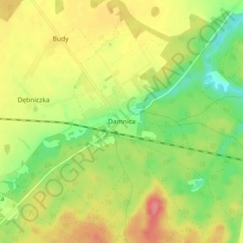
Name: Hebrondamnitz topographic map, elevation, terrain.
Average elevation: 71 m
Minimum elevation: 35 m
Maximum elevation: 107 m
Other topographic maps
Click on a map to view its topography, its elevation and its terrain.
Garder See
Polen > Woiwodschaft Pommern > Landkreis Stolp > Groß Garde
Garder See, Groß Garde, Gemeinde Schmolsin, Landkreis Stolp, Woiwodschaft Pommern, Polen
Average elevation: 0 m