
Månafossen topographic map
Interactive map
Click on the map to display elevation.
About this map
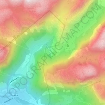
Name: Månafossen topographic map, elevation, terrain.
Location: Månafossen, Gjesdal, Rogaland, Norway (58.85764 6.38441 58.85774 6.38451)
Average elevation: 409 m
Minimum elevation: 31 m
Maximum elevation: 802 m
Other topographic maps
Click on a map to view its topography, its elevation and its terrain.
Stavanger
The municipality of Stavanger is located in a coastal landscape, bordering the sea to the west and Boknafjorden in the northeast. The Byfjorden and Gandsfjorden run along the east side of the city. It is part of the Low-Jæren, a flat area of land consisting mostly of marsh, sand, and stone aur, that ranges…
Average elevation: 42 m