Geolocate

Strand topographic map

Click on the map to display elevation.

About this map

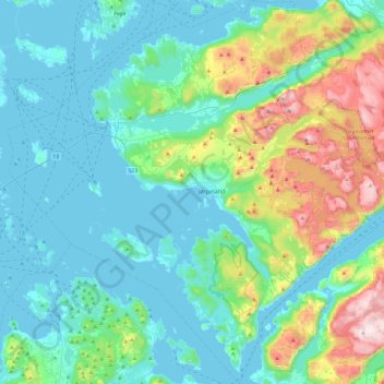
Name: Strand topographic map, elevation, terrain.

Location: Strand, Rogaland, Norway (58.89611 5.78396 59.14330 6.24860)

Average elevation: 170 m

Minimum elevation: -1 m

Maximum elevation: 833 m

Other topographic maps

Click on a map to view its topography, its elevation and its terrain.

Ølen

Norway > Rogaland

Average elevation: 143 m

Suldalsosen

Norway > Rogaland

Average elevation: 315 m

Aukland

Norway > Rogaland

Average elevation: 43 m

Årabrot

Norway > Rogaland > Haugesund

Average elevation: 16 m

Tau

Norway > Rogaland

Average elevation: 58 m

Månafossen

Norway > Rogaland

Average elevation: 409 m

Austevik

Norway > Rogaland > Håvik

Average elevation: 14 m

Egersund

Norway > Rogaland

Average elevation: 68 m

Aukland

Norway > Rogaland

Average elevation: 260 m

Gear up for your next adventure:

Outdoor Coffee Makers - Enjoy quality coffee at the summit of your favorite peak
🥾Heavy Duty Hiking Boots - Ankle-supporting boots for carrying heavy packs on steep contours
🧤Thermal Hiking Gloves - Keep your hands warm and functional during high-altitude winter treks
🎒Hiking Backpacks - Backpacks designed for hiking and trekking
📱Tablet Tripod Mounts - Steady platforms for viewing digital maps or taking long exposures

As an Amazon Associate, this site earns from qualifying purchases at no extra cost to you.