Geolocate

Meransen - Maranza topographic map

Click on the map to display elevation.

Meransen - Maranza

Meransen (Italian: Maranza) is a village in South Tyrol, Italy, in the Mühlbach municipality between Pustertal and Eisacktal. It located on the slopes of the Gitschberg mountain at an altitude of 1,414 m (4,639 ft).

About this map
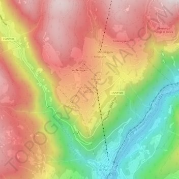
Name: Meransen - Maranza topographic map, elevation, terrain.

Location: Meransen - Maranza, Mühlbach - Rio di Pusteria, Eisacktal - Valle Isarco, South Tyrol, Trentino – Alto Adige/Südtirol, 39037, Italy (46.79335 11.64200 46.83335 11.68200)

Average elevation: 1,279 m

Minimum elevation: 714 m

Maximum elevation: 1,743 m

Gear up for your next adventure:

🔋Rechargeable Batteries - Eco-friendly power for high-drain GPS units and flashlights
💧Personal Water Filters - Drink safely from streams and lakes identified on your map
🎒40L Day Hiking Backpacks - Comfortable packs with hydration support for long days exploring topographic peaks
🎒Dry Bags - Waterproof bags for outdoor gear
🌧️Rain Jackets - Waterproof jackets for hiking

As an Amazon Associate, this site earns from qualifying purchases at no extra cost to you.