
Piz Argient topographic map
Interactive map
Click on the map to display elevation.
About this map
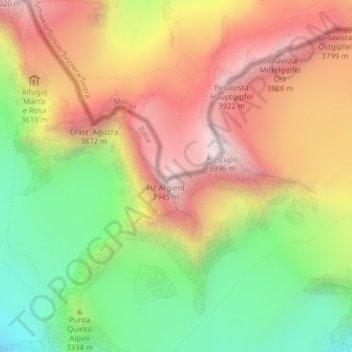
Name: Piz Argient topographic map, elevation, terrain.
Average elevation: 3,417 m
Minimum elevation: 2,872 m
Maximum elevation: 3,948 m
Other topographic maps
Click on a map to view its topography, its elevation and its terrain.
Piz Zupò
Zwitserland > Grauwbunderland > Pontresina
Piz Zupò, Pontresina, Maloja, Grauwbunderland, 7504, Zwitserland
Average elevation: 3,473 m
Crast' Agüzza
Zwitserland > Grauwbunderland > Pontresina
Crast' Agüzza, Pontresina, Maloja, Grauwbunderland, 7504, Zwitserland
Average elevation: 3,424 m