
Make a donation
Gear up for your next adventure:
As an Amazon Associate, this site earns from qualifying purchases at no extra cost to you.
Villa Elisa topographic map
Click on the map to display elevation.
Make a donation
Gear up for your next adventure:
As an Amazon Associate, this site earns from qualifying purchases at no extra cost to you.
Villa Elisa
The topographic characteristics of the Central Department vary among curves of 58 to 250 meters over the sea level. Villa Elisa has sandy soil covered by vegetation.
Make a donation
Gear up for your next adventure:
As an Amazon Associate, this site earns from qualifying purchases at no extra cost to you.
About this map
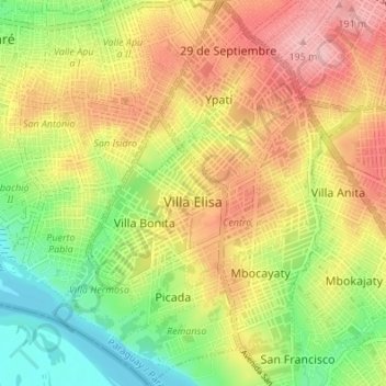
Name: Villa Elisa topographic map, elevation, terrain.
Location: Villa Elisa, Central Department, Región Oriental, Paraguay (-25.40069 -57.61461 -25.33941 -57.56680)
Average elevation: 120 m
Minimum elevation: 48 m
Maximum elevation: 192 m
Make a donation
Gear up for your next adventure:
As an Amazon Associate, this site earns from qualifying purchases at no extra cost to you.