
Make a donation
Gear up for your next adventure:
As an Amazon Associate, this site earns from qualifying purchases at no extra cost to you.
Haslach topographic map
Click on the map to display elevation.
Make a donation
Gear up for your next adventure:
As an Amazon Associate, this site earns from qualifying purchases at no extra cost to you.
Haslach
Das Pfarrdorf Haslach liegt etwa 1,7 km südwestlich vom Traunsteiner Stadtzentrum, etwa 8 km östlich des Chiemsees und 15 km nördlich der Chiemgauer Alpen auf einer Höhe von 610 m ü. NN.
Make a donation
Gear up for your next adventure:
As an Amazon Associate, this site earns from qualifying purchases at no extra cost to you.
About this map
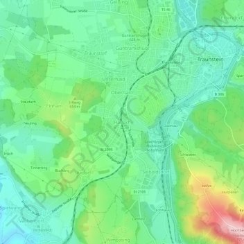
Name: Haslach topographic map, elevation, terrain.
Average elevation: 616 m
Minimum elevation: 550 m
Maximum elevation: 774 m
Make a donation
Gear up for your next adventure:
As an Amazon Associate, this site earns from qualifying purchases at no extra cost to you.
Other topographic maps
Click on a map to view its topography, its elevation and its terrain.
83278
Deutschland > Bayern > Landkreis Traunstein > Traunstein > Gemarkung Wolkersdorf
Average elevation: 601 m
Rettenbach
Deutschland > Bayern > Landkreis Traunstein > Traunstein > Rettenbach
Average elevation: 597 m