Geolocate

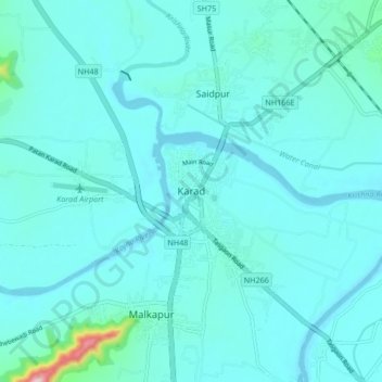
Karad topographic map

Click on the map to display elevation.

Karad

Karad is located at 17°17′N 74°12′E / 17.28°N 74.2°E / 17.28; 74.2. It has an average elevation of 566 metres (1857 feet). Karad is located near Agashiva caves 17°14′15″N 74°09′07″E / 17.237506°N 74.15205°E / 17.237506; 74.15205.

Wikipedia (CC-BY-SA 3.0)

About this map

Name: Karad topographic map, elevation, terrain.

Location: Karad, Satara, Maharashtra, 415100, India (17.24521 74.14221 17.32521 74.22221)

Average elevation: 580 m

Minimum elevation: 552 m

Maximum elevation: 853 m

Gear up for your next adventure:

🐍Australian Snake Bite Kits - Specific pressure immobilization bandages for Australian venomous snakes
👄SPF Lip Balm - Prevent sun and wind-burnt lips on mountain ridges
🥾Hiking Shoes - Lightweight hiking shoes for day hikes
🧦Merino Wool Hiking Socks - Moisture-wicking socks to prevent blisters during long topographic surveys
🧼Clip-on Hand Sanitizer - Maintain hygiene when water for washing is scarce

As an Amazon Associate, this site earns from qualifying purchases at no extra cost to you.