
Make a donation
Gear up for your next adventure:
As an Amazon Associate, this site earns from qualifying purchases at no extra cost to you.
Hopewell Township topographic map
Click on the map to display elevation.
Make a donation
Gear up for your next adventure:
As an Amazon Associate, this site earns from qualifying purchases at no extra cost to you.
Hopewell Township
The topography of the township is one of rolling hills and small mountains, with The Sourlands encompassing the northern and western portions of the township and flatter terrain further southeast. Baldpate Mountain, in the western part of the township, is the highest hill, at 480 feet (150 m) above sea level. The lowest elevation is between 20 and 40 feet, located where Jacobs Creek joins the Delaware River in the southwestern corner of the township.
Make a donation
Gear up for your next adventure:
As an Amazon Associate, this site earns from qualifying purchases at no extra cost to you.
About this map
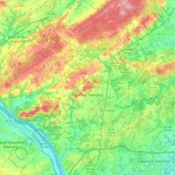
Name: Hopewell Township topographic map, elevation, terrain.
Average elevation: 72 m
Minimum elevation: 5 m
Maximum elevation: 176 m
Make a donation
Gear up for your next adventure:
As an Amazon Associate, this site earns from qualifying purchases at no extra cost to you.
Other topographic maps
Click on a map to view its topography, its elevation and its terrain.
Robbinsville
United States > New Jersey > Mercer County > Robbinsville Township
Average elevation: 32 m