
Make a donation
Gear up for your next adventure:
As an Amazon Associate, this site earns from qualifying purchases at no extra cost to you.
Franklin topographic map
Click on the map to display elevation.
Make a donation
Gear up for your next adventure:
As an Amazon Associate, this site earns from qualifying purchases at no extra cost to you.
About this map
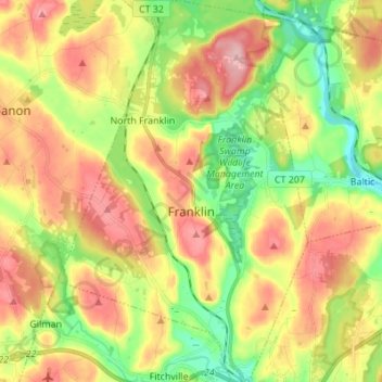
Name: Franklin topographic map, elevation, terrain.
Average elevation: 95 m
Minimum elevation: 21 m
Maximum elevation: 176 m
Make a donation
Gear up for your next adventure:
As an Amazon Associate, this site earns from qualifying purchases at no extra cost to you.
Other topographic maps
Click on a map to view its topography, its elevation and its terrain.
Austrailia Beach
United States > Connecticut > Southeastern Connecticut Planning Region > Mystic
Average elevation: 19 m
High Rock
United States > Connecticut > Southeastern Connecticut Planning Region > Waterford
Average elevation: 39 m
Chesterfield
United States > Connecticut > Southeastern Connecticut Planning Region > Montville
Average elevation: 77 m
North Franklin
United States > Connecticut > Southeastern Connecticut Planning Region
Average elevation: 103 m
Make a donation
Gear up for your next adventure:
As an Amazon Associate, this site earns from qualifying purchases at no extra cost to you.
Flanders
United States > Connecticut > Southeastern Connecticut Planning Region > East Lyme
Average elevation: 43 m
Manitock Spring
United States > Connecticut > Southeastern Connecticut Planning Region > Waterford
Average elevation: 26 m
Quiambaug
United States > Connecticut > Southeastern Connecticut Planning Region > Mystic
Average elevation: 8 m
Make a donation
Gear up for your next adventure:
As an Amazon Associate, this site earns from qualifying purchases at no extra cost to you.
Oakdale
United States > Connecticut > Southeastern Connecticut Planning Region > Montville
Average elevation: 141 m
Jordan Village
United States > Connecticut > Southeastern Connecticut Planning Region > Waterford
Average elevation: 27 m
Giants Neck
United States > Connecticut > Southeastern Connecticut Planning Region > East Lyme
Average elevation: 9 m
Pepperbox Hill
United States > Connecticut > Southeastern Connecticut Planning Region > Waterford
Average elevation: 18 m
Make a donation
Gear up for your next adventure:
As an Amazon Associate, this site earns from qualifying purchases at no extra cost to you.
Austrailia Beach
United States > Connecticut > Southeastern Connecticut Planning Region > Mystic
Average elevation: 19 m
Montville Center
United States > Connecticut > Southeastern Connecticut Planning Region > Montville
Average elevation: 106 m
Four Corners
United States > Connecticut > Southeastern Connecticut Planning Region > Montville
Average elevation: 108 m
Taftville Reservoir #1 Dam
United States > Connecticut > Southeastern Connecticut Planning Region > Norwich
Average elevation: 75 m
Make a donation
Gear up for your next adventure:
As an Amazon Associate, this site earns from qualifying purchases at no extra cost to you.
Blue Lake
United States > Connecticut > Southeastern Connecticut Planning Region > North Stonington
Average elevation: 106 m
Blackboys
United States > Connecticut > Southeastern Connecticut Planning Region > East Lyme
Average elevation: 38 m
Quiambaug
United States > Connecticut > Southeastern Connecticut Planning Region > Mystic
Average elevation: 8 m
Make a donation
Gear up for your next adventure:
As an Amazon Associate, this site earns from qualifying purchases at no extra cost to you.
Quaker Hill
United States > Connecticut > Southeastern Connecticut Planning Region > Waterford
Average elevation: 35 m
Center Groton
United States > Connecticut > Southeastern Connecticut Planning Region > Groton
Average elevation: 49 m
Uncasville
United States > Connecticut > Southeastern Connecticut Planning Region > Montville
Average elevation: 40 m
Chesterfield
United States > Connecticut > Southeastern Connecticut Planning Region > Montville
Average elevation: 77 m
Make a donation
Gear up for your next adventure:
As an Amazon Associate, this site earns from qualifying purchases at no extra cost to you.
Austrailia Beach
United States > Connecticut > Southeastern Connecticut Planning Region > Mystic
Average elevation: 19 m
Flanders
United States > Connecticut > Southeastern Connecticut Planning Region > East Lyme
Average elevation: 43 m
Huntley Island
United States > Connecticut > Southeastern Connecticut Planning Region > East Lyme
Average elevation: 7 m
Austrailia Beach
United States > Connecticut > Southeastern Connecticut Planning Region > Mystic
Average elevation: 19 m
Make a donation
Gear up for your next adventure:
As an Amazon Associate, this site earns from qualifying purchases at no extra cost to you.
Hanover Reservoir
United States > Connecticut > Southeastern Connecticut Planning Region > Hanover
Average elevation: 91 m
North Stonington
United States > Connecticut > Southeastern Connecticut Planning Region
Average elevation: 73 m
Mystic
United States > Connecticut > Southeastern Connecticut Planning Region > Stonington
Average elevation: 17 m
Avery Hill
United States > Connecticut > Southeastern Connecticut Planning Region > Ledyard
Average elevation: 52 m
Make a donation
Gear up for your next adventure:
As an Amazon Associate, this site earns from qualifying purchases at no extra cost to you.
Fitch Corner
United States > Connecticut > Southeastern Connecticut Planning Region > Montville
Average elevation: 51 m
Seal Rocks
United States > Connecticut > Southeastern Connecticut Planning Region > Stonington
Average elevation: 37 m