Geolocate

Pierson topographic map

Click on the map to display elevation.

About this map

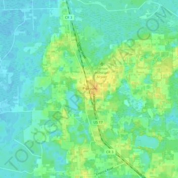
Name: Pierson topographic map, elevation, terrain.

Location: Pierson, Volusia County, Florida, 32180, United States (29.20373 -81.48978 29.27440 -81.40170)

Average elevation: 14 m

Minimum elevation: 5 m

Maximum elevation: 32 m

Other topographic maps

Click on a map to view its topography, its elevation and its terrain.

Jones Island

United States > Florida > Volusia County

Average elevation: 13 m

Gear up for your next adventure:

🔦LED Torches - LED torches for outdoor use
📕Hiking Guide Books - Guides for hiking trails
🧭Global Orienteering Compass - High-precision liquid-filled compasses for accurate map reading and navigation
🐍Snake Gaiters - Protection against snake bites
🐍Australian Snake Bite Kits - Specific pressure immobilization bandages for Australian venomous snakes

As an Amazon Associate, this site earns from qualifying purchases at no extra cost to you.