
Make a donation
Gear up for your next adventure:
As an Amazon Associate, this site earns from qualifying purchases at no extra cost to you.
Meizhou topographic map
Click on the map to display elevation.
Make a donation
Gear up for your next adventure:
As an Amazon Associate, this site earns from qualifying purchases at no extra cost to you.
Meizhou
Meizhou has a humid subtropical climate (Köppen Cfa), with short, mild, overcast winters and long, very hot, humid summers. The monthly daily average temperature in January is 12.6 °C (54.7 °F), and in July is 28.9 °C (84.0 °F). From April to June, rainfall is the heaviest and most frequent. Though striking typhoons do not affect the area as much as the coast, the mountainous topography means that flooding is a serious concern.
Make a donation
Gear up for your next adventure:
As an Amazon Associate, this site earns from qualifying purchases at no extra cost to you.
About this map
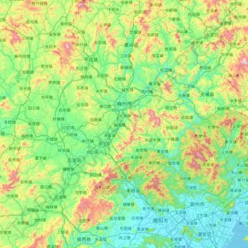
Name: Meizhou topographic map, elevation, terrain.
Location: Meizhou, Guangdong Province, China (23.37618 115.31160 24.94071 116.93493)
Average elevation: 297 m
Minimum elevation: -1 m
Maximum elevation: 1,479 m
Make a donation
Gear up for your next adventure:
As an Amazon Associate, this site earns from qualifying purchases at no extra cost to you.
Other topographic maps
Click on a map to view its topography, its elevation and its terrain.
Make a donation
Gear up for your next adventure:
As an Amazon Associate, this site earns from qualifying purchases at no extra cost to you.