
Swain topographic map
Click on the map to display elevation.
About this map
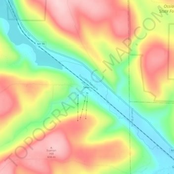
Name: Swain topographic map, elevation, terrain.
Average elevation: 503 m
Minimum elevation: 386 m
Maximum elevation: 619 m
Other topographic maps
Click on a map to view its topography, its elevation and its terrain.
Village of Canaseraga
United States > New York > Allegany County > Town of Burns
Average elevation: 427 m
Village of Alfred
United States > New York > Allegany County
According to the United States Census Bureau, the village has a total area of 1.2 square miles (3.1 km2), all land. A small stream, Kanakadea Creek, flows through the center of the village, then to the Canisteo River, part of the Susquehanna River watershed. The topography is steep hill country, part of the…
Average elevation: 597 m