
Torre Bormida topographic map
Interactive map
Click on the map to display elevation.
About this map
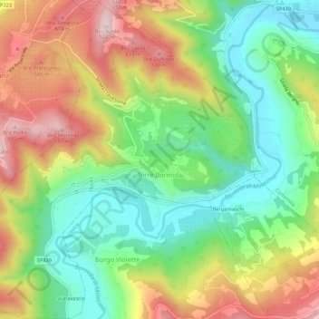
Name: Torre Bormida topographic map, elevation, terrain.
Location: Torre Bormida, Cuneo, Piemont, Italien (44.54542 8.12011 44.58357 8.17034)
Average elevation: 422 m
Minimum elevation: 250 m
Maximum elevation: 658 m
Der Ort liegt auf einer Höhe von 391 m über dem Meeresspiegel. Das Gemeindegebiet umfasst eine Fläche von 7 km². Die Nachbargemeinden sind Bergolo, Bosia, Cortemilia, Cravanzana, Feisoglio und Levice.
Other topographic maps
Click on a map to view its topography, its elevation and its terrain.
Castelletto Uzzone
Castelletto Uzzone, Cuneo, Piemont, Italien
Average elevation: 572 m
Nova
Italien > Piemont > Cuneo > Valloriate
Nova, Valloriate, Cuneo, Piemont, Italien
Average elevation: 963 m
Casteldelfino
Casteldelfino, Cuneo, Piemont, Italien
Average elevation: 1,977 m
Case Materassi
Italien > Piemont > Cuneo > Prà di Roburent
Case Materassi, Prà di Roburent, Roburent, Cuneo, Piemont, Italien
Average elevation: 1,123 m
Monviso
Italien > Piemont > Cuneo > Pontechianale
Monviso, Pontechianale, Cuneo, Piemont, Italien
Average elevation: 2,985 m