Geolocate

Allen topographic map

Click on the map to display elevation.

About this map

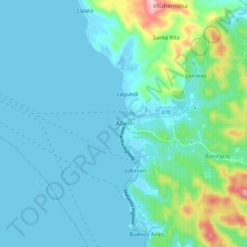
Name: Allen topographic map, elevation, terrain.

Location: Allen, Northern Samar, Eastern Visayas, 6405, Philippines (12.46112 124.24266 12.54112 124.32266)

Average elevation: 33 m

Minimum elevation: -5 m

Maximum elevation: 208 m

Other topographic maps

Click on a map to view its topography, its elevation and its terrain.

Biri

Philippines > Northern Samar

Average elevation: 1 m

Catubig River

Philippines > Northern Samar

Average elevation: 38 m

Catarman

Philippines > Northern Samar

Average elevation: 50 m

Sitio Rabbit

Philippines > Northern Samar > Victoria

Average elevation: 27 m

Tarnate

Philippines > Northern Samar > San Vicente

Average elevation: 27 m

Sitio Alegria

Philippines > Northern Samar > San Isidro

Average elevation: 18 m

Capul Island

Philippines > Northern Samar > Capul

Average elevation: 14 m

Palanit

Philippines > Northern Samar

Average elevation: 52 m

Capul

Philippines > Northern Samar

Average elevation: 5 m

Capul Island

Philippines > Northern Samar > Capul

Average elevation: 14 m

Catarman

Philippines > Northern Samar

Average elevation: 51 m

Catarman

Philippines > Northern Samar

Average elevation: 51 m

Gear up for your next adventure:

👣Snake & Scrub Gaiters - Protection against spinifex, mud, and snakes while walking off-track
👄SPF Lip Balm - Prevent sun and wind-burnt lips on mountain ridges
👖Convertible Hiking Trousers - Zip-off legs to adapt to changing temperatures throughout the day
🥾Hiking Shoes - Lightweight hiking shoes for day hikes
📱Tablet Tripod Mounts - Steady platforms for viewing digital maps or taking long exposures

As an Amazon Associate, this site earns from qualifying purchases at no extra cost to you.