Geolocate

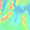
Enseada topographic map

Click on the map to display elevation.

About this map

Name: Enseada topographic map, elevation, terrain.

Location: Enseada, Maragogipe, Bahia, Região Nordeste, 44220-000, Brasil (-12.88617 -38.84618 -12.84617 -38.80618)

Average elevation: 24 m

Minimum elevation: -1 m

Maximum elevation: 144 m

Other topographic maps

Click on a map to view its topography, its elevation and its terrain.

Coqueiros

Brasil > Bahia > Maragogipe

Average elevation: 131 m

São Roque do Paraguaçu

Brasil > Bahia > Maragogipe

Average elevation: 42 m

Gear up for your next adventure:

🖼️Scratch-off Australia Map - Track the regions and peaks you have explored geographically
🥤Hydration Packs - Hydration systems for hiking
🧣Merino Neck Gaiters - Versatile headwear for warmth, sun protection, or dust filtering
⛺Ultralight Solo Tents - Compact shelters for multi-day topographic surveying expeditions
🧊Insulated Stainless Steel Flasks - Keep water cold for 24 hours in the heat or coffee hot in the cold

As an Amazon Associate, this site earns from qualifying purchases at no extra cost to you.