
Tötensen topographic map
Interactive map
Click on the map to display elevation.
About this map
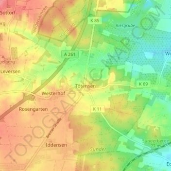
Name: Tötensen topographic map, elevation, terrain.
Average elevation: 72 m
Minimum elevation: 30 m
Maximum elevation: 113 m
Other topographic maps
Click on a map to view its topography, its elevation and its terrain.
Ashausen
Deutschland > Niedersachsen > Harburg
Ashausen, Stelle, Harburg, Niedersachsen, 21435, Deutschland
Average elevation: 14 m
Winsen (Luhe)
Deutschland > Niedersachsen > Harburg
Winsen (Luhe), Harburg, Niedersachsen, 21423, Deutschland
Average elevation: 12 m