
Make a donation
Gear up for your next adventure:
As an Amazon Associate, this site earns from qualifying purchases at no extra cost to you.
Bulgan topographic map
Click on the map to display elevation.
Make a donation
Gear up for your next adventure:
As an Amazon Associate, this site earns from qualifying purchases at no extra cost to you.
About this map
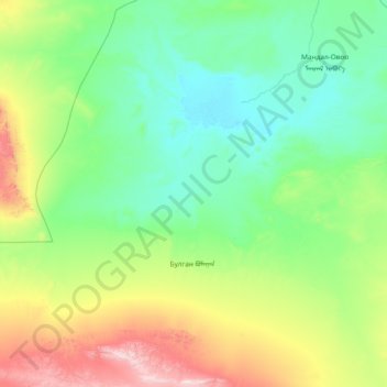
Name: Bulgan topographic map, elevation, terrain.
Location: Bulgan, Ömnögovi, Mongolia (43.75046 102.93243 44.82789 104.18901)
Average elevation: 1,316 m
Minimum elevation: 1,031 m
Maximum elevation: 2,546 m
Make a donation
Gear up for your next adventure:
As an Amazon Associate, this site earns from qualifying purchases at no extra cost to you.
Other topographic maps
Click on a map to view its topography, its elevation and its terrain.
Overlooking the steppe and sand dunes
Mongolia > Ömnögovi > Sevrey > Sevrey
Average elevation: 1,796 m
Make a donation
Gear up for your next adventure:
As an Amazon Associate, this site earns from qualifying purchases at no extra cost to you.
Make a donation
Gear up for your next adventure:
As an Amazon Associate, this site earns from qualifying purchases at no extra cost to you.