
Make a donation
Gear up for your next adventure:
As an Amazon Associate, this site earns from qualifying purchases at no extra cost to you.
Springboro topographic map
Click on the map to display elevation.
Make a donation
Gear up for your next adventure:
As an Amazon Associate, this site earns from qualifying purchases at no extra cost to you.
About this map
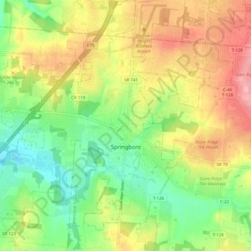
Name: Springboro topographic map, elevation, terrain.
Location: Springboro, Warren County, Ohio, 45066, United States (39.52063 -84.27600 39.59685 -84.19103)
Average elevation: 263 m
Minimum elevation: 210 m
Maximum elevation: 326 m
Make a donation
Gear up for your next adventure:
As an Amazon Associate, this site earns from qualifying purchases at no extra cost to you.
Other topographic maps
Click on a map to view its topography, its elevation and its terrain.
Make a donation
Gear up for your next adventure:
As an Amazon Associate, this site earns from qualifying purchases at no extra cost to you.
Corwin M. Nixon Pine Hill Lakes Park
United States > Ohio > Warren County > Mason
Average elevation: 250 m