
Make a donation
Gear up for your next adventure:
As an Amazon Associate, this site earns from qualifying purchases at no extra cost to you.
Seaford topographic map
Click on the map to display elevation.
Make a donation
Gear up for your next adventure:
As an Amazon Associate, this site earns from qualifying purchases at no extra cost to you.
About this map
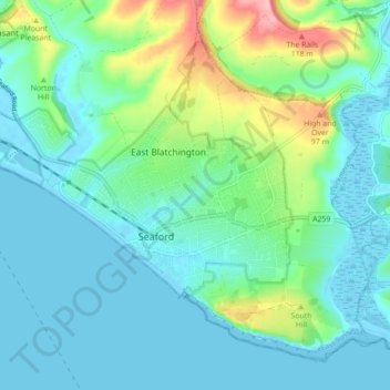
Name: Seaford topographic map, elevation, terrain.
Location: Seaford, Lewes, East Sussex, England, United Kingdom (50.75434 0.06667 50.80221 0.15447)
Average elevation: 28 m
Minimum elevation: -3 m
Maximum elevation: 130 m
Make a donation
Gear up for your next adventure:
As an Amazon Associate, this site earns from qualifying purchases at no extra cost to you.
Other topographic maps
Click on a map to view its topography, its elevation and its terrain.
Make a donation
Gear up for your next adventure:
As an Amazon Associate, this site earns from qualifying purchases at no extra cost to you.
Make a donation
Gear up for your next adventure:
As an Amazon Associate, this site earns from qualifying purchases at no extra cost to you.
South Heighton
United Kingdom > England > East Sussex > Lewes > South Heighton
Average elevation: 37 m
Make a donation
Gear up for your next adventure:
As an Amazon Associate, this site earns from qualifying purchases at no extra cost to you.
Kingston Near Lewes
United Kingdom > England > East Sussex > Lewes > Kingston Near Lewes
Average elevation: 65 m