Geolocate

Meridian topographic map

Click on the map to display elevation.

About this map

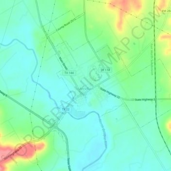
Name: Meridian topographic map, elevation, terrain.

Location: Meridian, Bosque County, Texas, 76665, United States (31.90688 -97.68065 31.94417 -97.63095)

Average elevation: 245 m

Minimum elevation: 219 m

Maximum elevation: 310 m

Other topographic maps

Click on a map to view its topography, its elevation and its terrain.

Cayote

United States > Texas > Bosque County

Average elevation: 225 m

Kopperl

United States > Texas > Bosque County

Average elevation: 176 m

Laguna Park

United States > Texas > Bosque County

Average elevation: 175 m

Mosheim

United States > Texas > Bosque County

Average elevation: 286 m

Gear up for your next adventure:

🧥Insulated Down Jackets - High warmth-to-weight ratio for cold nights in the high country
🔋Solar Power Banks - Solar chargers for outdoors
🎒Tactical Waist Packs - Quick access to your compass, phone, and snacks while walking
🆘Personal Locator Beacons (PLB) - Satellite emergency beacons for life-saving help in areas with no mobile coverage
GPS Watches - GPS watches for outdoor sports

As an Amazon Associate, this site earns from qualifying purchases at no extra cost to you.