
Make a donation
Gear up for your next adventure:
As an Amazon Associate, this site earns from qualifying purchases at no extra cost to you.
Coburg topographic map
Click on the map to display elevation.
Make a donation
Gear up for your next adventure:
As an Amazon Associate, this site earns from qualifying purchases at no extra cost to you.
Coburg
Die nächsten Großstädte sind Erfurt, etwa 80 km Luftlinie nördlich, Würzburg, etwa 90 km südwestlich, sowie Erlangen und Nürnberg, etwa 75 bzw. 90 km südlich. Die Höhenlage des Marktplatzes ist 296 m ü. NN, die der Veste 451 m ü. NN.
Make a donation
Gear up for your next adventure:
As an Amazon Associate, this site earns from qualifying purchases at no extra cost to you.
About this map
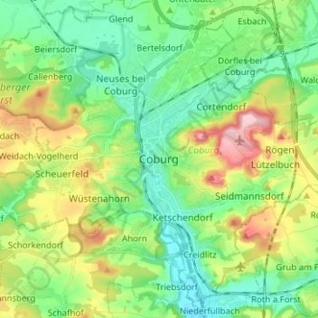
Name: Coburg topographic map, elevation, terrain.
Location: Coburg, Bayern, 96450, Deutschland (50.21811 10.92446 50.29811 11.00446)
Average elevation: 337 m
Minimum elevation: 277 m
Maximum elevation: 462 m
Make a donation
Gear up for your next adventure:
As an Amazon Associate, this site earns from qualifying purchases at no extra cost to you.