
Make a donation
Gear up for your next adventure:
As an Amazon Associate, this site earns from qualifying purchases at no extra cost to you.
Matzingen topographic map
Click on the map to display elevation.
Make a donation
Gear up for your next adventure:
As an Amazon Associate, this site earns from qualifying purchases at no extra cost to you.
About this map
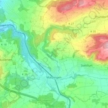
Name: Matzingen topographic map, elevation, terrain.
Location: Matzingen, Bezirk Frauenfeld, Thurgau, 9548, Schweiz (47.50705 8.90756 47.55263 8.94838)
Average elevation: 508 m
Minimum elevation: 420 m
Maximum elevation: 678 m
Make a donation
Gear up for your next adventure:
As an Amazon Associate, this site earns from qualifying purchases at no extra cost to you.
Other topographic maps
Click on a map to view its topography, its elevation and its terrain.
Kartause Ittingen
Schweiz > Thurgau > Bezirk Frauenfeld > Warth-Weiningen > Warth
Average elevation: 429 m
Iselisberg
Schweiz > Thurgau > Bezirk Frauenfeld > Uesslingen-Buch > Uesslingen
Average elevation: 439 m
Make a donation
Gear up for your next adventure:
As an Amazon Associate, this site earns from qualifying purchases at no extra cost to you.
Schloss Glarisegg
Schweiz > Thurgau > Bezirk Frauenfeld > Steckborn > Glarisegg
Average elevation: 467 m