
Aleppo Governorate topographic map
Interactive map
Click on the map to display elevation.
Aleppo Governorate
The average elevation of the terrain is 379 metres (1,243 ft). The surface gradually slopes down in north-south and west-east directions, undulating gently with an amplitude of 10–30 m for each wave. The lowlands are covered with combined Paleozoic and Mesozoic sediments that average 4–5 km in thickness over the whole surface.
About this map
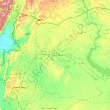
Name: Aleppo Governorate topographic map, elevation, terrain.
Location: Aleppo Governorate, Syria (35.38381 36.54368 36.92412 38.72058)
Average elevation: 439 m
Minimum elevation: 77 m
Maximum elevation: 2,182 m
Other topographic maps
Click on a map to view its topography, its elevation and its terrain.
Has
Hass (Arabic: حَاسٌّ, romanized: Ḥāss) is a town in northwestern Syria, administratively part of the Ma'arrat al-Numan District of the Idlib Governorate. The town has an altitude of 630 meters above sea level. According to the Syria Central Bureau of Statistics, Hass had a population of 9,595 in the…
Average elevation: 591 m