
Quierschied topographic map
Interactive map
Click on the map to display elevation.
About this map
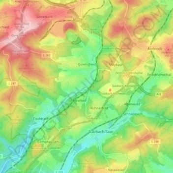
Name: Quierschied topographic map, elevation, terrain.
Average elevation: 314 m
Minimum elevation: 209 m
Maximum elevation: 442 m
Other topographic maps
Click on a map to view its topography, its elevation and its terrain.
Bezirk Dudweiler
Allemagne > Sarre > Regionalverband Saarbrücken > Sarrebruck
Bezirk Dudweiler, Sarrebruck, Regionalverband Saarbrücken, Sarre, Allemagne
Average elevation: 261 m
Dorf im Warndt
Allemagne > Sarre > Regionalverband Saarbrücken > Grande-Rosselle
Dorf im Warndt, Grande-Rosselle, Regionalverband Saarbrücken, Sarre, Allemagne
Average elevation: 265 m
Dorf im Warndt
Allemagne > Sarre > Regionalverband Saarbrücken > Dorf im Warndt
Dorf im Warndt, Grande-Rosselle, Regionalverband Saarbrücken, Sarre, 66352, Allemagne
Average elevation: 256 m