
Make a donation
Gear up for your next adventure:
As an Amazon Associate, this site earns from qualifying purchases at no extra cost to you.
Argés topographic map
Click on the map to display elevation.
Make a donation
Gear up for your next adventure:
As an Amazon Associate, this site earns from qualifying purchases at no extra cost to you.
About this map
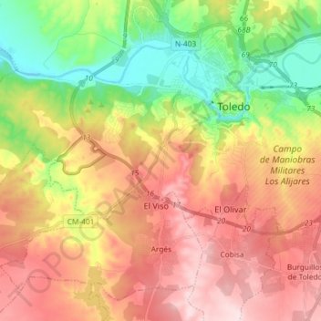
Name: Argés topographic map, elevation, terrain.
Location: Argés, Toledo, Castilla-La Mancha, 45122, España (39.78850 -4.18389 39.88563 -4.03800)
Average elevation: 581 m
Minimum elevation: 432 m
Maximum elevation: 730 m
Make a donation
Gear up for your next adventure:
As an Amazon Associate, this site earns from qualifying purchases at no extra cost to you.
Other topographic maps
Click on a map to view its topography, its elevation and its terrain.
Make a donation
Gear up for your next adventure:
As an Amazon Associate, this site earns from qualifying purchases at no extra cost to you.
Toledo
España > Castilla-La Mancha > Toledo > Toledo
La extensión de su término municipal es de 232,1 km². La altitud del centro de la ciudad es de 516 m sobre el nivel del mar, mientras que la altitud del municipio varía desde los 429 metros en el último tramo en el municipio del río Tajo hasta los 697 metros en el sur, en la cima de una colina muy…
Average elevation: 590 m
Make a donation
Gear up for your next adventure:
As an Amazon Associate, this site earns from qualifying purchases at no extra cost to you.
Make a donation
Gear up for your next adventure:
As an Amazon Associate, this site earns from qualifying purchases at no extra cost to you.
Las Huertas del Sauceral
España > Castilla-La Mancha > Las Huertas del Sauceral
Average elevation: 560 m
Make a donation
Gear up for your next adventure:
As an Amazon Associate, this site earns from qualifying purchases at no extra cost to you.
Valdeganga de Cuenca
España > Castilla-La Mancha > Valdetórtola > Valdeganga de Cuenca
Average elevation: 974 m
Make a donation
Gear up for your next adventure:
As an Amazon Associate, this site earns from qualifying purchases at no extra cost to you.
Make a donation
Gear up for your next adventure:
As an Amazon Associate, this site earns from qualifying purchases at no extra cost to you.
Make a donation
Gear up for your next adventure:
As an Amazon Associate, this site earns from qualifying purchases at no extra cost to you.
Make a donation
Gear up for your next adventure:
As an Amazon Associate, this site earns from qualifying purchases at no extra cost to you.
Corral de la Muela Marojales
España > Castilla-La Mancha > Santa María del Val
Average elevation: 1,367 m
Make a donation
Gear up for your next adventure:
As an Amazon Associate, this site earns from qualifying purchases at no extra cost to you.
Make a donation
Gear up for your next adventure:
As an Amazon Associate, this site earns from qualifying purchases at no extra cost to you.
Make a donation
Gear up for your next adventure:
As an Amazon Associate, this site earns from qualifying purchases at no extra cost to you.
Make a donation
Gear up for your next adventure:
As an Amazon Associate, this site earns from qualifying purchases at no extra cost to you.
Make a donation
Gear up for your next adventure:
As an Amazon Associate, this site earns from qualifying purchases at no extra cost to you.
Make a donation
Gear up for your next adventure:
As an Amazon Associate, this site earns from qualifying purchases at no extra cost to you.
Tazona
España > Castilla-La Mancha > Socovos
Tazona se encuentra a una altitud de 702 m s. n. m.
Average elevation: 711 m
Make a donation
Gear up for your next adventure:
As an Amazon Associate, this site earns from qualifying purchases at no extra cost to you.
Make a donation
Gear up for your next adventure:
As an Amazon Associate, this site earns from qualifying purchases at no extra cost to you.
Make a donation
Gear up for your next adventure:
As an Amazon Associate, this site earns from qualifying purchases at no extra cost to you.
Make a donation
Gear up for your next adventure:
As an Amazon Associate, this site earns from qualifying purchases at no extra cost to you.
Make a donation
Gear up for your next adventure:
As an Amazon Associate, this site earns from qualifying purchases at no extra cost to you.
La Olmeda de Jadraque
España > Castilla-La Mancha > La Olmeda de Jadraque > La Olmeda de Jadraque
Average elevation: 994 m
Majaelrayo
España > Castilla-La Mancha > Majaelrayo > Majaelrayo
La localidad se encuentra a una altitud de 1186 msnm.
Average elevation: 1,253 m
Make a donation
Gear up for your next adventure:
As an Amazon Associate, this site earns from qualifying purchases at no extra cost to you.
Make a donation
Gear up for your next adventure:
As an Amazon Associate, this site earns from qualifying purchases at no extra cost to you.
Parque Natural Hayedo Tejera Negra
España > Castilla-La Mancha > Cantalojas
Average elevation: 1,384 m
Make a donation
Gear up for your next adventure:
As an Amazon Associate, this site earns from qualifying purchases at no extra cost to you.
Ribatajada
España > Castilla-La Mancha > Sotorribas
La localidad está situada a una altitud de 768 m sobre el nivel del mar.
Average elevation: 958 m
Make a donation
Gear up for your next adventure:
As an Amazon Associate, this site earns from qualifying purchases at no extra cost to you.
Ocejón
España > Castilla-La Mancha > Valverde de los Arroyos
Es el pico principal de la parte más meridional de la sierra de Ayllón, constituyendo, con sus 2049 m, la máxima elevación de la sierra del Ocejón o del Robledal, donde ocupa una situación meridional, extendiéndose este desde el propio pico Ocejón hacia el norte. Es una montaña constituida por piedra…
Average elevation: 1,632 m
Muriel
España > Castilla-La Mancha > Tamajón
La localidad está situada en las últimas estribaciones de la sierra de Ayllón, en la margen derecha del río Sorbe. El pueblo está ubicado en un ensanchamiento del valle, protegido por las laderas de este, orientado al sur como muchos otros pueblos serranos. Está a una altitud de 870 m sobre el nivel del mar.
Average elevation: 981 m
Make a donation
Gear up for your next adventure:
As an Amazon Associate, this site earns from qualifying purchases at no extra cost to you.
Valle de Repizquillos
España > Castilla-La Mancha > Guadalajara > Almonacid de Zorita
Average elevation: 889 m
Los Sifones
España > Castilla-La Mancha > Talavera > Talavera de la Reina > Los Sifones
Average elevation: 374 m
Make a donation
Gear up for your next adventure:
As an Amazon Associate, this site earns from qualifying purchases at no extra cost to you.