
Make a donation
Gear up for your next adventure:
As an Amazon Associate, this site earns from qualifying purchases at no extra cost to you.
Grenchen topographic map
Click on the map to display elevation.
Make a donation
Gear up for your next adventure:
As an Amazon Associate, this site earns from qualifying purchases at no extra cost to you.
Grenchen
The municipality is the capital of the Lebern District. It is the second largest city in the Canton of Solothurn. The municipality stretches from the hamlet of Staad along the Aare river, (at an elevation of 430 m (1,410 ft)) to the first mountain range of the Jura Mountains (the Oberer Grenchenberg is 1,348 m (4,423 ft)).
Make a donation
Gear up for your next adventure:
As an Amazon Associate, this site earns from qualifying purchases at no extra cost to you.
About this map
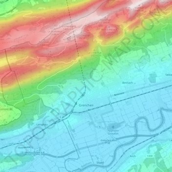
Name: Grenchen topographic map, elevation, terrain.
Average elevation: 705 m
Minimum elevation: 424 m
Maximum elevation: 1,411 m
Make a donation
Gear up for your next adventure:
As an Amazon Associate, this site earns from qualifying purchases at no extra cost to you.