
Make a donation
Gear up for your next adventure:
As an Amazon Associate, this site earns from qualifying purchases at no extra cost to you.
Woodbridge topographic map
Click on the map to display elevation.
Make a donation
Gear up for your next adventure:
As an Amazon Associate, this site earns from qualifying purchases at no extra cost to you.
Woodbridge
The Suffolk Travler suggests a similar origin to The Dictionary but originating from a bridge over a hollow way that leads from Woodbridge Market Place to the Ipswich. But this is disputed by Rev. Thomas Carthew, then perpetual curate of Woodrbidge who points out that the bridge had existed for less than a hundred years at that point and therefore was not old enough to be the source of the name. He instead suggests Oden or Woden (Odin) and Burgh, Bury, or Brigg (town). The Topographical Dictionary of England suggests a combination of Woden and Bryge.
Make a donation
Gear up for your next adventure:
As an Amazon Associate, this site earns from qualifying purchases at no extra cost to you.
About this map
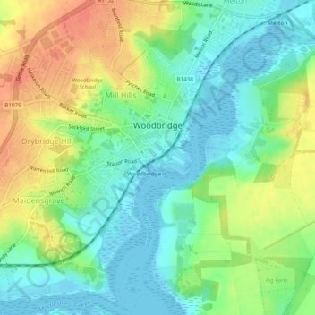
Name: Woodbridge topographic map, elevation, terrain.
Location: Woodbridge, East Suffolk, Suffolk, England, United Kingdom (52.07639 1.28439 52.10577 1.32901)
Average elevation: 19 m
Minimum elevation: -5 m
Maximum elevation: 46 m
Make a donation
Gear up for your next adventure:
As an Amazon Associate, this site earns from qualifying purchases at no extra cost to you.
Other topographic maps
Click on a map to view its topography, its elevation and its terrain.
Site of old Orfordness Lighthouse
United Kingdom > England > Suffolk > East Suffolk > Orford
Average elevation: 0 m
Make a donation
Gear up for your next adventure:
As an Amazon Associate, this site earns from qualifying purchases at no extra cost to you.
Rendlesham UFO Landing Site #2
United Kingdom > England > Suffolk > East Suffolk > Butley Abbey
Average elevation: 14 m
Make a donation
Gear up for your next adventure:
As an Amazon Associate, this site earns from qualifying purchases at no extra cost to you.
Gunton Sands
United Kingdom > England > Suffolk > East Suffolk > Lowestoft > Corton
Average elevation: 10 m
Make a donation
Gear up for your next adventure:
As an Amazon Associate, this site earns from qualifying purchases at no extra cost to you.
Make a donation
Gear up for your next adventure:
As an Amazon Associate, this site earns from qualifying purchases at no extra cost to you.
Sutton Hoo Archeological Site
United Kingdom > England > Suffolk > East Suffolk > Sutton
Average elevation: 19 m
Lowestoft Inner Harbour
United Kingdom > England > Suffolk > East Suffolk > Lowestoft > Oulton Broad
Average elevation: 8 m
Make a donation
Gear up for your next adventure:
As an Amazon Associate, this site earns from qualifying purchases at no extra cost to you.
Make a donation
Gear up for your next adventure:
As an Amazon Associate, this site earns from qualifying purchases at no extra cost to you.
Eygpt Wood
United Kingdom > England > Suffolk > East Suffolk > Trimley St Martin
Average elevation: 16 m
Eygpt Wood
United Kingdom > England > Suffolk > East Suffolk > Trimley St Martin
Average elevation: 16 m