Geolocate

Fargo topographic map

Click on the map to display elevation.

About this map

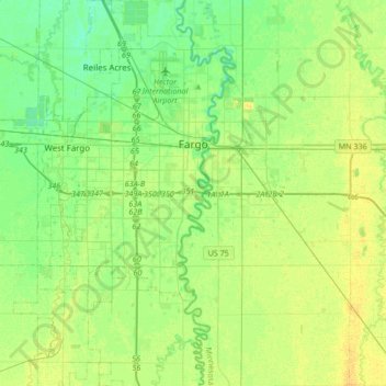
Name: Fargo topographic map, elevation, terrain.

Location: Fargo, Cass County, North Dakota, United States (46.70285 -96.90377 46.97695 -96.75284)

Average elevation: 277 m

Minimum elevation: 268 m

Maximum elevation: 287 m

Other topographic maps

Click on a map to view its topography, its elevation and its terrain.

Fargo

United States > North Dakota > Cass County > Fargo

Average elevation: 277 m

Gear up for your next adventure:

🏃Compression Recovery Socks - Reduce leg fatigue after heavy days of elevation gain
🎽Hiking Clothing - Breathable clothing for hiking
🧊Insulated Stainless Steel Flasks - Keep water cold for 24 hours in the heat or coffee hot in the cold
🧤Hiking Gloves - Protective gloves for outdoor use
📻Handheld UHF Radios - Critical communication for groups in the Australian outback

As an Amazon Associate, this site earns from qualifying purchases at no extra cost to you.