
Thank you for supporting this site ❤️
Make a donation
Make a donation
Gear up for your next adventure:
As an Amazon Associate, this site earns from qualifying purchases at no extra cost to you.
Palmetto topographic map
Click on the map to display elevation.
Thank you for supporting this site ❤️
Make a donation
Make a donation
Gear up for your next adventure:
As an Amazon Associate, this site earns from qualifying purchases at no extra cost to you.
About this map
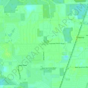
Name: Palmetto topographic map, elevation, terrain.
Location: Palmetto, Fort Bend County, Texas, 77545, United States (29.51579 -95.48633 29.55579 -95.44633)
Average elevation: 22 m
Minimum elevation: 16 m
Maximum elevation: 26 m
Thank you for supporting this site ❤️
Make a donation
Make a donation
Gear up for your next adventure:
As an Amazon Associate, this site earns from qualifying purchases at no extra cost to you.
Other topographic maps
Click on a map to view its topography, its elevation and its terrain.
Sienna (Brazos River) Park
United States > Texas > Fort Bend County > Missouri City
Average elevation: 20 m