
Thank you for supporting this site ❤️
Make a donation
Make a donation
Gear up for your next adventure:
As an Amazon Associate, this site earns from qualifying purchases at no extra cost to you.
Akfadou topographic map
Click on the map to display elevation.
Thank you for supporting this site ❤️
Make a donation
Make a donation
Gear up for your next adventure:
As an Amazon Associate, this site earns from qualifying purchases at no extra cost to you.
About this map
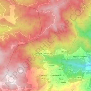
Name: Akfadou topographic map, elevation, terrain.
Location: Akfadou, Chemini District, Bejaia, 06411, Algeria (36.61843 4.56480 36.69691 4.65250)
Average elevation: 1,122 m
Minimum elevation: 366 m
Maximum elevation: 1,616 m
Thank you for supporting this site ❤️
Make a donation
Make a donation
Gear up for your next adventure:
As an Amazon Associate, this site earns from qualifying purchases at no extra cost to you.