
Mekele topographic map
Interactive map
Click on the map to display elevation.
About this map
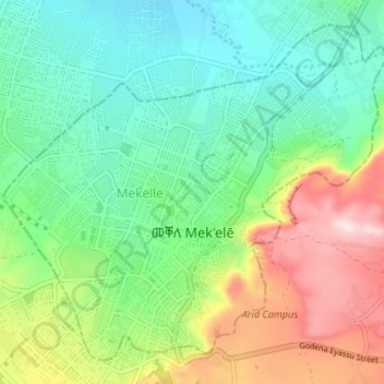
Name: Mekele topographic map, elevation, terrain.
Location: Mekele, Tigré, Éthiopie (13.47492 39.44380 13.53166 39.51051)
Average elevation: 2,090 m
Minimum elevation: 1,969 m
Maximum elevation: 2,330 m
Mekele est une ville située dans la zone Tigré Sud de la région Tigré. Elle se trouve à 2 060 m d'altitude et à 780 km au nord d'Addis Abeba.
Other topographic maps
Click on a map to view its topography, its elevation and its terrain.
Northern Stelae Field
Northern Stelae Field, Center Market, Aksoum, Central Tigray, Tigré, Éthiopie
Average elevation: 2,199 m
Uaza Plateau
Uaza Plateau, Southern Tigray, Tigré, Éthiopie
Average elevation: 2,303 m
Hawzen Tekle Haymanot Bete
Hawzen Tekle Haymanot Bete, Hawzien, Eastern Tigray, Tigré, Éthiopie
Average elevation: 2,217 m