Geolocate

Li County topographic map

Click on the map to display elevation.

About this map

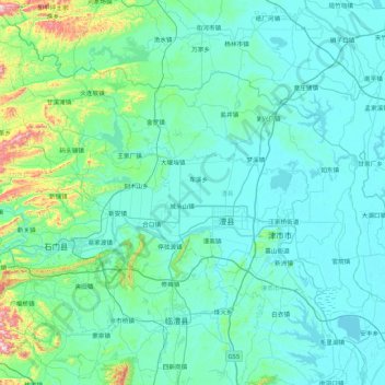
Name: Li County topographic map, elevation, terrain.

Location: Li County, Changde, Hunan, China (29.42132 111.21447 29.95676 112.07128)

Average elevation: 104 m

Minimum elevation: 25 m

Maximum elevation: 791 m

Other topographic maps

Click on a map to view its topography, its elevation and its terrain.

Xinpu

China > Hunan > Changde

Average elevation: 259 m

Gear up for your next adventure:

📡Weather Radios - Emergency weather radios
🗺️Topographic Maps - Detailed maps for hiking and navigation
🔌Fast Charging Adapters - Quickly top up all your gear before heading back into the field
🔪Camping Knives - Multi-purpose outdoor knives
🔥Windproof Plasma Lighters - USB rechargeable lighters that work in high-altitude winds

As an Amazon Associate, this site earns from qualifying purchases at no extra cost to you.